Lire cet article en français
German Naturparks and French Parcs Naturels Régionaux (PNR) are project breeding grounds where eco-friendly agriculture, outdoor tourism, and recreational activities can coexist, as we explored in part 1. In this second part, we will discuss the more successful trajectory of certain French PNRs, which, along with some German nature parks, have been awarded a “Geo park” label by UNESCO. A Geopark label isn’t the only way for PNRs to shine: the Cévennes National Park, unique in many ways, collaborates with the surrounding PNRs to bring to life sustainable land planning concepts such as ecological corridors. And we’ll look at all this with mind to the vote on the Nature Restoration Law on July 12, 2023. An analysis by Marie-Lise Breure Montagne.
Read part 1 of this analysis
Geoparks: a PNR labeling for rock stars*
*aka the protection and enhancement of natural and geological heritage.
PNRs cover 17% of the French metropolitan territory (compared to the 27% of German NaturParks). Even though the national federation of PNRs promotes the “Valeurs Parc Naturel Régional” brand, these types of territories sometimes face negative publicity, with lists of pollution accidents and other development projects that contradict sustainable development issues.
Take a documentary aired on France TV in early 2023, Elodie Martinie-Cousty, expressed her dismay at seeing the beginnings of a construction project that used explosives to break ground in the heart of the Sainte-Baume PNR. She also called into question the figures put forward by the government: The French government claims that more than 30% of the French territory is in protected zones. This happens to be in line with the objectives of the 2015 COP on Biodiversity in Montreal. To Martine-Cousty, it seems quite amazing that the country has reach 30% of terrestrial areas under protection before the 2030 deadline. It is by adding up areas with different protection measures (PNR, Natura 2000 excluding PNR, National Parks) that we can achieve such a nice score!.

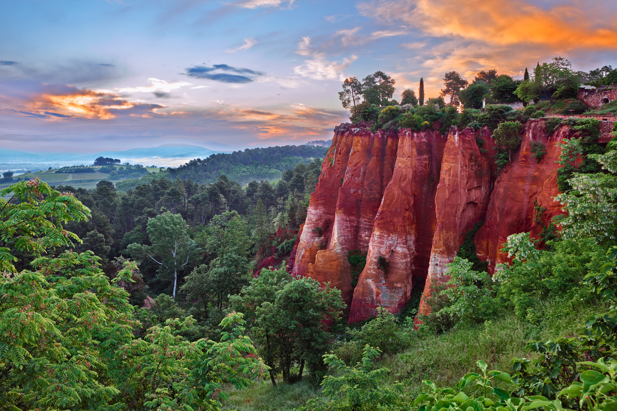
In this context, some French PNRs have sought additional recognition of their natural assets by becoming Geoparks (see figure n°1). Geoparks are territories that have remarkable geological heritage of international value. Landscapes, rocks, and fossils bear witness to the Earth’s history for more than 4 billion years: whether or not you have geological knowledge, it is a source of wonder. Geoparks also illustrate the relationship between humans and the Earth, as well as the complex link between the nature of the subsoil and the type of biodiversity that develops there. Each site of geological or heritage interest is called a geosite (see figure n°2).

According to C. Portal and I. Aubron in Pour Magazine, in France, the Lubéron Geopark is one of the four first geoparks that formed the basis of the European network, along with the Vulkaneifel Geopark in Germany, Lesvos in Greece, and Maestrazgo in Spain. Territories applying for the geopark label must rely on an existing network of stakeholders (parks, intercommunalities, reserves, Natura 2000 sites, etc.) that, in supporting the project, offer an operational management structure.
The administrators of Vulkaneifel park, located in a German volcanic area, have, like in Luberon or the Bauges ranges, chosen to be designated as a UNESCO Geopark: “The population [of the Vulkaneifel geopark] is approximately 83,000 inhabitants living in 180 villages and a few small towns. The rural region is the most important mountain tourist area in the Rhineland-Palatinate state. Over the past 30 years, efforts to promote economic development have focused on the region’s unique geological heritage. The tourism intensity rate is five times the German average*”
The European Geoparks Network lists 94 geoparks in 28 European countries, including Iceland, Great Britain, Norway, and Turkey, four large countries rich in geological wonders, although not EU members. It states that they are “Territories of Resilience“.
The geographical scope of the first French geoparks is often based on the boundaries of regional nature parks (i.e. geoparks of Luberon, Massif des Bauges, Monts d’Ardèche, Causses du Quercy) or partially adjacent to them. Regional nature parks, which are familiar with the natural and geological heritage they contain, may have facilitated applications in the system.
Again for Pour Magazine, C. Portal and I. Aubron say,
“Just like regional nature parks, the geopark label is a tool for territorial development – particularly geo-tourism – whose objectives are in line with those of regional nature parks: to promote a concerted sustainable development project based on the protection and enhancement of natural and cultural heritage.”
Both labels are complementary tools for enhancing the fundamental resources of the territory in support of local, and often touristic, development, as shown by the example of Vulkaneifel. The Geopark label allows for an upgrade of two categories in the IUCN typology: from category V for the regional nature park to category III for a geopark.
By having an internationally managed label like UNESCO, these local initiatives can be seen as a competition for international tourist attractiveness, or conversely as a relocalization of tourist wonderment.
The Cévennes National Park
A Nature Restoration hot spot for over a century, now witnessing the impact of climate change
The Cévennes National Park was created by the French State in September 1970, and its charter renewed in 2013. It covers the natural region of the Cévennes and is mainly located in Lozère and Gard departments, as well as in Ardèche. Therefore, it extends across two administrative regions: Occitanie and Auvergne Rhône-Alpes.
The Cévennes National Park has several distinctive features compared to other national parks: it is the only French national park located in mid-mountain areas, and therefore, it is the only metropolitan national park whose core is permanently inhabited with economic and agricultural activities. This is despite a very low population density, and agriculture known as HVN: High Nature Value, see figure n°3.

Today, it is one of the regions in Europe that has experienced the greatest biological enrichment since its creation. Many species have naturally recolonized habitats from which they had disappeared, like otters, herons, black woodpeckers, and at the same time, the park has reintroduced certain species, like deer, beavers, vultures and capercaillies. A reintroduction operation of the bearded vulture has been taking place since 2013.
The Cévennes National Park was designated as a biosphere reserve by UNESCO in 1985, and a part of the protected territory is included in the “Causses Cévennes,” listed as a World Heritage site by UNESCO.The park has a statutory mandate to protect heritage and biodiversity, educate young audiences, and promote the value of this heritage through human activities such as agriculture, forestry, and tourism, which respect these remarkable natural spaces.
Mount Aigoual is one of the two major massifs in the Cévennes mountains, following Mount Lozère, located in the core zone of the Cévennes National Park. Although the summit at an altitude of 1565 meters is located in Gard, the northern slope falls in Lozère: Mount Aigoual is one of the high points on the watershed between the Mediterranean and the Atlantic. A special feature of the Aigoual massif is that it was reforested at the end of the 19th century to prevent erosion and destructive floods in its foothills.
The construction of the meteorological observatory at the summit of Aigoual dates back to the late 19th century. It is currently the last inhabited high-altitude weather station for monitoring Cévennes episodes (intense late-summer rainfall, nearly tropical, when the temperature of the Mediterranean Sea is high; if the Mediterranean Sea heats up too much, the phenomenon no longer occurs, as in the year 2022). Rivers that are dry in summer become torrents in flood (figure n°4)… or not (figure n°5: Mount Aigoual, an essential place for panoramic views: if the sky is clear, the view extends from the Alps to the Mediterranean coast, and even to the Pyrenees).


The IPAMAC
Or, an example of horizontal and multi-decade cooperation between the Cévennes National Park and 11 Regional Natural Parks (figure n°6), embodying the concept of ecological networks.
The IPAMAC, created in 1998, is a network built well beyond traditional administrative boundaries. However, it was the DATAR, a government agency for territorial cohesion, renamed ANCT, and the Massif-Central Commission, established by the Mountain Law of 1985, that initiated the cooperation, along with the director of the Cévennes National Park and the director of the Livradois-Forez Regional Park. Originally, the IPAMAC included nine regional parks, and then in 2018, it expanded to include the Aubrac and Périgord-Limousin Regional Nature Parks.

General delegate of IMAPAC, for Pour Magazine explains that,
“The network was formed around shared issues, including the mountains. It was never intended to become a political representation at any level. The driving force behind it are projects, achievements, and the contribution to solving a number of common questions we have […] One of the rules we set for ourselves is that the projects undertaken must be of interest to a majority of the parks […]. Initially, three themes were identified: tourism, territorial planning, and water management,”
The green and blue network (called the “trame verte et bleue” in French) is a concept that dates back to the 1980s-1990s in French-speaking countries. It partly stems from preparatory work for the Rio Earth Summit, landscape ecology, and the project for a pan-European ecological network prepared by the Council of Europe. It is a policy for biodiversity preservation aiming to maintain and restore ecological continuities in territories: the Green and Blue Network (TVB). It aims to slow down the biodiversity erosion resulting from land artificialization and fragmentation. In France, the Grenelle Environment Forum (2007) will revive the concept of the green and blue network, with the objective of territorializing the French green and blue network through the regional ecological coherence schemes, with the blue network relying in particular on the water management and development schemes.
The director of IPAMAC explains:
“In 2007, we started mapping the ecological network of the Massif Central, as part of a call for projects from the Ministry of the Environment. The objective was to have tools for automatic mapping and aerial photos […]. It was necessary to stabilize the methods and find their translation and usefulness in the regional ecological coherence schemes Naturally, this led us to the issue of biodiversity. At the end of this project, the question arose as to what was the emblematic environment of the Massif Central… it was the “open herbaceous environments” (MOH), permanent meadows for grazing.”
Thus, the MOH program was born, aiming to influence farmers’ practices. Their work also focused on ancient forests and the black network, a dark sky initiative meant to protect nocturnal species from light pollution.
The financing of this transregional network is partly ensured through European subsidies:
“Since 2016, we have been operating with triennial agreements with the Massif Central Commission, which include actions funded at an average level of 60%, with the remainder mainly coming from the European Regional Development Fund (ERDF)” (figure 7).
A careful reading of the IMAPAC working area (figure n°6) reveals a “gap”: the location of the Regional Natural Park of the sources and gorges of Haut-Allier, never materialized. Focused more on priority themes such as water, agriculture, eco-tourism, the railway line, and natural heritage, the preparatory work for this project in the Haut-Allier was rejected by the President of the Auvergne Rhône Alpes region. In July 2016, the regional council decided to repeal the previous assembly’s decision to approve the park project, citing opposition from the Chamber of Agriculture. Despite a 4-year legal battle before the administrative court, the project remains shelved. An undeniable fact is that regional councils are the main co-financers of Regional Natural Parks and the managing authorities of LEADER funds.
The president of the region believed that the operation of the park would be too expensive. This virtuous concern does not prevent him from having costly projects for new road layouts, in order to save “3 minutes,” a project that has been severely criticized by the Environmental Authority.
When a regional elected official does not like to hear about “nature,” it is evident in his policies, which are based on outdated territorial development schemes: the ribbon of asphalt, as the magical formula for rural development.

Conclusion
Geoparks can embody a possibility for tourism in the Anthropocene, and can become territories of resilience. Geological wonders can act as a balm for eco-anxiety, by putting into perspective what is being prepared. More prosaically, they indicate that European territories including Germany and France feel the need to differentiate themselves by seeking a label from a “supra” European entity like UNESCO -at the same time gaining two levels in the IUCN classification (category V to category III).
In this year 2023, when the political agenda in Brussels has been marked by the narrow passage of the Nature Restoration Law, it is useful if not essential to highlight long-term initiatives such as that of IPAMAC (network of parks in the Massif Central). While the Auvergne Rhône Alpes region is the 2nd metropolitan region supported by the ERDF; a very small green bar is dedicated to the protection of Biodiversity and Nature. In this Europe of the Regions, there are horizontal and inter-regional cooperations, beyond traditional administrative borders, on complex and essential subjects such as biodiversity.
In 2023-2024, the Rural Resilience project embarks on a new phase of joining the policy dots while continuing to nurture what we have built together, and widening the lens from France to Germany and the broader Europe. To learn more, visit the project page, and follow ARC2020 on LinkedIn, Twitter, Facebook or Instagram.
Keep Reading…
Water as a Common Good .. and climate risks, a common destiny – Part 2/2
Access to Land: More Resilient Agriculture – Without Any EU Legislation? (Part 2)
Access to Land: Looking to Europe to Secure Local Farmland? Part 1
Beyond the Harvest: Health Effects of Pesticides on French Farmers
France | Democratising Food Policy – Tweaking The Financial Toolbox
Ernährungsrat: The democratic potential of Food Policy Councils in Germany